According to the Federal Highway Administration (FHWA), USA more than 1.4 million highway crashes occur under adverse weather and road conditions each year.
Maybe nothing can be done to change the weather, but something can be done about measuring and alleviating its effect on road conditions. By observing and predicting the impacts of weather on highways, transportation experts who operate the Nation’s roadways can determine appropriate management strategies, such as applying anti-icing chemicals, reducing speed limits, or closing hazardous areas, to make driving safer during and after inclement weather.
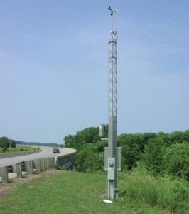
To collect real-time weather observations along highways, transportation managers use environmental sensor stations (ESS) that are strategically located to help them identify appropriate maintenance and traffic management strategies. These sensor stations are the building blocks of a road weather information system (RWIS) – which includes the hardware, software, and communications equipment used to collect and transfer road weather data to a central location.
Road weather information systems, originally developed to address winter weather, now operate year-round and monitor a variety of weather and pavement conditions. An ESS may have multiple sensors that detect atmospheric conditions. For example, it can provide data for informing motorists about strong crosswinds. Pavement sensors, on the other hand, monitor conditions such as wet, snowy, icy, or flooded surfaces. Still other sensors provide data on subsurface conditions, such as soil temperatures.
Other road weather data of interest include precipitation, humidity, and visibility; atmospheric pressure; the concentrations of chemicals on pavements from de-icing treatments; and solar and terrestrial radiation to determine the potential for nighttime cooling. Water-level sensors may be needed in flood-prone areas and along coastal roadways.
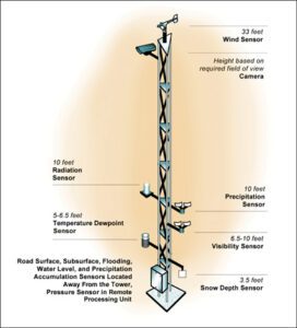
A typical ESS installation includes a thermometer to measure air temperature, a hygrometer for water vapor (dewpoint or relative humidity), an anemometer and wind vane, and a pavement sensor to monitor temperature, freeze point, and chemical concentration. A rain gauge and infrared sensor can measure precipitation occurrence, type, and intensity. By using sensors and video cameras mounted on a tower or next to it, operations and maintenance personnel can determine appropriate strategies and evaluate the outcome of those strategies.
But sensors do have limitations. There are no reliable instruments to remotely measure roadway conditions such as snowpack depth. Also, there are no automated sensors to provide observations of thunderstorms, tornadoes, waterspouts, and sun glare.
The sites that provide data on local weather phenomena have different requirements than the regional sites that support broad, real-time monitoring across a large geographic area or road segment. Local sites are selected to detect road weather conditions of interest for a specific road segment, bridge, or other transportation-related feature. Conditions of interest are typically the result of topographic variations, road construction techniques, pavement types, roadway geometry, or subsurface characteristics.
Uses and Benefits
ESS data enable us to monitor and react to changing road conditions in order to maintain safe driving conditions as best as possible. In addition to the key benefit of improving road safety during and after storms, ESS data supply information that traffic and weather response managers need to maintain vehicle flow and mobility during adverse weather, and thereby help increase the productivity of the Nation’s transportation system.
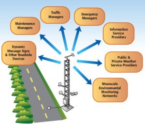
Other key benefits of ESS data include supplying the information that traffic managers need to provide traveler information. Local, State, and Federal disaster response agencies also may use the information to assess and manage emergencies and response actions. Transportation managers use ESS data to support road maintenance activities.
Planning should address data requirements first and then address how to satisfy power and communications requirements. Power options include commercial connections, wind power, or solar with batteries. Commercial power is usually the most economical and reliable. Solar power can support nominal loads but typically is incapable of sustaining heavy power consumption for heated sensors. North Dakota has successfully used wind power for a number of ESS installations.
In some cases, the sensors can be located near other intelligent transportation system (ITS) devices such as traffic counters, dynamic message signs, and traffic signal controllers to share power and communications costs. For critical sites, backup sources of power or communications may be needed.
Communications options include hardwired telephone, cellular, copper wire, fiber-optic cable, wireless, radio, microwave, or satellite. Important factors in the selection of the communication method and equipment are how much data are included in each observation (bandwidth) and the frequency of transmittal of observations. For sites with low bandwidth requirements (that is, no video camera or infrequent reporting), telephone lines or some type of wireless communication may be more economical than hardwired options. For high data volumes, a hardwired system (wire or fiber optic) appears more appropriate.
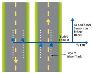
For historical polling (data retrieval), road weather data are stored in the remote processing unit (RPU) and retrieved at set times, such as the top of the hour and every 15 minutes thereafter. This process differs from polling the RPU to obtain only the current road weather observations.
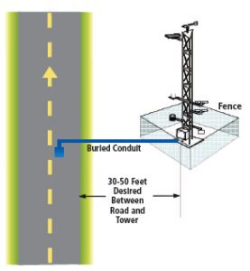
Regarding aesthetic considerations, following the criteria related to maintaining adequate distances from obstructions can result in a sensor tower that is very obvious. Pre-siting discussions with the surrounding stakeholders may forestall any aesthetic problems.
Siting too close or too far from the roadway may seriously complicate maintenance procedures or unnecessarily jeopardize the safety of maintenance personnel. Likewise, extra security measures may be needed in areas where the threat of vandalism is present. Possibilities include a security fence around the tower, anti-climb panels, or even security cameras.
Over the years, periodic reevaluation is needed to ensure that the data from the site are still valid and that the metadata are still correct. Construction projects and vegetation growth may change the representativeness and usefulness of ESS locations. This reevaluation can be part of an annual preventive maintenance program for sensor calibration.
An RWIS-ESS can be and is a very useful tool in myriad disciplines. The solution required for the installation at your desired road has to be customized after thorough study of requirements by the team of experts of Buraq Integrated Solutions. Would you like to design and implement the Road Weather Information System?Contact our team of experts.